

A tense meteorological drama is unfolding across the United Kingdom. As the nation swelters under the legacy of its driest January-June period since 1976 and three successive heatwaves, the Met Office has issued a cascade of yellow weather warnings for violent thunderstorms and torrential downpours. This dangerous paradox – drought-baked landscapes facing deluge – defines the UK’s precarious summer of 2025.
The Warnings: What’s Happening Right Now
The Met Office weather warnings are stark and urgent:
- Northern Ireland: Warned until 8pm Thursday (17 July) for severe thunderstorms.
- Northeast England: A yellow warning for thunderstorms Friday afternoon (12pm-8pm, 18 July).
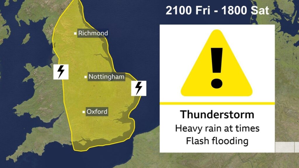
- Much of England: A major yellow thunderstorm warning in effect from 9pm Friday (18 July) until 6pm Saturday (19 July), encompassing London, the Midlands, the Southeast, and extending northwards.
Chief Meteorologist Jason Kelly states unequivocally: “More warnings could be issued for the weekend and early next week. Keep an eye on the Met Office forecast for updates as the picture develops.”
Why the High Risk? The Science Behind the Storms
This volatile situation stems from a dramatic atmospheric shift:
- The Jet Stream Shift: The jet stream has plunged southwards, straddling the UK and driving low-pressure systems our way.
- Warm, Humid Airmass: Winds are dragging exceptionally warm and moisture-laden air northwards from France and Spain.
- Atmospheric Instability: Cool air high in the atmosphere is overriding this humid surface air. This creates massive instability – the essential fuel for intense thunderstorms.
- The Drought Factor: Critically, soils across England and East Wales are bone-dry after months of deficient rainfall. Hard-baked ground cannot absorb sudden heavy rain, turning it into rapid, dangerous runoff and dramatically increasing the flash flood risk.
What the Warnings Mean: Impacts and Dangers
The Met Office thunderstorm warnings spell out significant hazards:
- Torrential Rain: 20-30mm of rain could fall in less than one hour widely within warning areas. Isolated spots could see a staggering 60-90mm within 3 hours – potentially over a month’s worth of rain in a very short time 138. Sky Weather Producer Joanna Robinson emphasizes: “The rain will be torrential in places… with 60-90 mm in less than three hours for some isolated spots.”
- Sudden Flooding: Rapid runoff due to dry ground poses the most severe threat. This can lead to:
- Road closures and deep, dangerous floodwater.
- Communities becoming temporarily cut off.
- Flooding of homes and businesses.
- Travel Chaos: Spray, standing water, and flooding will make driving hazardous. Lightning strikes pose risks to rail infrastructure, potentially causing cancellations and delays.
- Power Cuts: Lightning strikes and gusty winds associated with storms can damage power lines.
- Additional Hazards: Frequent lightning, large hail, and sudden strong wind gusts.
The Heat Endures: A Muggy, Uncomfortable Backdrop
Crucially, these storms are not occurring in cool conditions. The humid airmass means temperatures remain high:
- Eastern England could still hit 30°C (86°F) or more on Friday.
- Overnight temperatures in the south may stay above a stifling 20°C.
- Met Office meteorologist Alex Burkill notes this combination will become “quite uncomfortable for some of us.”
While isolated spots in the southeast might technically qualify for a heatwave definition (three consecutive days above a local threshold), the Met Office stresses it won’t feel like previous heatwaves due to the humidity and storm risk. There are no official heat warnings currently issued – the focus is squarely on the thunderstorm threat.
The Drought Context: Why Rain Won’t Solve the Crisis
The arrival of heavy rain seems ironic given the widespread hosepipe bans and drought declarations (now including East and West Midlands, Yorkshire, and parts of the South). However, this rainfall pattern is the worst possible type for drought recovery:
- Runoff, Not Recharge: Intense bursts on dry ground run off rapidly into drains and rivers, overwhelming infrastructure and causing flooding before soaking deeply. Little water percolates down to recharge desperately low groundwater aquifers.
- Plant Uptake: Any water that does soak into near-surface soil is quickly absorbed by thirsty plants and trees, leaving reserves depleted.
- Reservoir Levels: National reservoir storage is at just 75.6% and falling, with Yorkshire particularly low at 53.8%. Short, sharp downpours won’t significantly replenish these large stores.
- The Long-Term Need: Helen Wakeham, Environment Agency Director, states: “To see a substantial recovery… we’d need a more sustained spell of much wetter weather, this is typically what we see during our autumn or winter.” Hosepipe bans are likely to persist well into autumn.
Weekend Outlook and Beyond: More Turmoil Likely
The unsettled theme dominates:
- Saturday: Heavy, thundery rain spreads northwards across England into Scotland. Further thunderstorms may develop in the south later.
- Sunday: Widespread showers and thunderstorms continue pushing northwards across the UK. Drier, brighter spells possible but feeling warm and humid, especially in the east/southeast.
- Monday & Tuesday: Showers and thunderstorms remain likely, particularly in the north and east. Temperatures near normal or warm.
- Midweek (23rd onwards): Tentative signs of conditions settling from the west, though eastern areas may still see showers. A slightly cooler northwesterly flow may develop, but temperatures still near or slightly above average. High pressure may build more strongly later in the week.
Further Met Office weather warnings are highly probable over the weekend and into next week as confidence in the location of the heaviest downpours increases.
Understanding Met Office Weather Warnings: The Colour Code
The Met Office issues warnings through the National Severe Weather Warning Service (NSWWS) based on impact, not just weather thresholds. They consider time of year, day, location, and ongoing events/sensitivities.
- Yellow (Current Situation): Severe weather is possible. Stay updated, plan ahead, and be aware of potential disruptions. Damage to property, travel delays, and short-term loss of utilities are possible. Action: Check forecasts, monitor warnings, plan journeys carefully, consider flood preparations if vulnerable.
- Amber: Increased likelihood of significant impacts. Greater disruption to travel, power cuts, damage to property, and potential risk to life. Action: Change plans, protect property, follow advice.
- Red: Extreme weather with high risk to life and widespread disruption. Action: Take immediate action to stay safe.
Staying Safe: Essential Advice During the Warnings
- Before the Storm:
- Check Forecasts: Regularly monitor the Met Office website, app, or trusted news sources like BBC Weather. Sign up for warnings.
- Travel Plans: Allow extra time, check routes for disruption before setting out. Avoid driving through floodwater – just 30cm can move a car. Be prepared for delays/cancellations on public transport.
- Property: Secure loose objects in gardens. Clear drains and gutters if safe to do so. If in a flood-prone area, know your flood plan and have an emergency kit ready (torch, batteries, water, medications, phone power bank, important documents).
- Power: Be prepared for potential power cuts.
- During the Storm:
- Shelter: Stay indoors if possible. Avoid unnecessary travel.
- Lightning: If caught outside, avoid open fields, hilltops, and isolated trees. Do not shelter under trees. If in a group, spread out. Avoid metal structures, water, and using landline phones.
- Floodwater: Never walk or drive through floodwater. It may be deeper, faster-moving, or contaminated than it appears. Just 15cm of fast-flowing water can knock you off your feet.
- Driving: Reduce speed, use headlights, increase braking distance. If visibility drops severely, find a safe place to pull over.
- After the Storm: Be aware of ongoing risks like flooding, damaged structures, or fallen power lines. Report dangers to authorities.
Climate Change: The Growing Extremes
This summer’s relentless pattern – record spring warmth, extreme heatwaves, severe drought, and now potentially dangerous flash flooding – fits within the broader trend of UK climate change. The State of the UK Climate Report 2024 confirms the UK is warming at approximately 0.25°C per decade. A recent Met Office study indicates UK heatwaves are becoming longer, hotter, and more frequent, with a 50-50 chance of the UK reaching 40°C again within the next 12 years. Marine heatwaves are also intensifying.
While attributing any single thunderstorm event to climate change requires complex analysis, the broader context is clear: a warming atmosphere holds more moisture (increasing potential rainfall intensity), and warmer sea surface temperatures around the UK (currently well above average) add energy and humidity, potentially fueling more intense storms.
Navigating the “Rain Bomb” Headlines
The term “rain bomb” has featured in sensational headlines alongside claims of “740-mile” storm systems. The Met Office clarifies this is not a meteorological term. While significant rainfall is forecast, the focus should be on the impacts outlined in their official warnings, not hyperbolic descriptions. Low-pressure systems bring fronts of varying lengths, and rainfall amounts will vary hugely even within warning areas. Trust the official Met Office weather warnings for accurate, impact-focused information.
Conclusion: Vigilance Required Amidst Weather Whiplash
The UK is experiencing a stark case of weather whiplash: transitioning rapidly from record-breaking heat and drought into a period dominated by thunderstorm warnings and flash flood risk. The current Met Office yellow warnings highlight a period of significant potential disruption and danger, particularly from Friday evening through Saturday.
The humid airmass means this won’t be a refreshing break, but an uncomfortable and hazardous interlude. Crucially, this rainfall pattern offers little respite for drought-stricken regions and stressed water supplies; it’s too intense, too localized, and falling on ground too hard to absorb it effectively.
Staying informed via official Met Office forecasts and heeding their warnings is paramount. Prepare for travel disruption, be vigilant for sudden flooding, and avoid taking unnecessary risks, particularly near floodwater or during lightning. This volatile weather pattern serves as a potent reminder of the UK’s increasingly complex climate challenges, where extreme heat and extreme rainfall are becoming more frequent features of our summers.